TRAIL RIDGE ROAD Photography Locations GPS Guide
Trail Ridge Road offers unparalleled opportunities for alpine photography, combining dramatic elevation changes, diverse ecosystems, and spectacular mountain vistas accessible by vehicle. From intimate wildflower macros to sweeping panoramic landscapes, America's highest paved road provides subjects and compositions that challenge and inspire photographers at every level. This comprehensive guide includes precise GPS coordinates, optimal timing, camera settings, and insider techniques for capturing the essence of Rocky Mountain National Park's crown jewel.
📸 PHOTOGRAPHY PARADISE
Trail Ridge Road crosses 13 distinct ecosystems, offering subjects from montane meadows to alpine tundra. The dramatic elevation gain from 7,500 to 12,183 feet creates unique lighting conditions and photographic opportunities found nowhere else in the accessible mountain world.
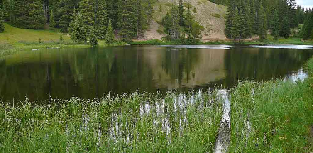
The serene beauty of Trail Ridge Road's alpine lakes provides endless opportunities for reflection photography and peaceful landscape compositions. The crystal-clear mountain waters mirror the surrounding coniferous forests and rolling hills, creating the perfect subjects for photographers seeking to capture the tranquil essence of Colorado's high country.
🗺️ Essential Photography Locations with GPS
1. Many Parks Curve (Mile 8.8)
GPS Coordinates: 40.3569°N, -105.6046°W
Elevation: 9,620 feet
Best Time: Sunrise (6:30-7:30 AM) and late afternoon (4:30-6:30 PM)
Subjects: Panoramic valley views, layered mountain ridges, elk herds
Composition Tips:
- Wide Angle: Use 14-24mm for full valley panoramic
- Telephoto: 70-200mm to isolate mountain layers and wildlife
- Foreground Elements: Include roadside wildflowers or aspen groves
- HDR Opportunities: High dynamic range during golden hour
Seasonal Highlights:
Spring (May-June): Snow-capped peaks with green valleys
Summer (July-August): Wildflower meadows, elk activity
Fall (September-October): Aspen gold against distant peaks
Winter (November-April): Road typically closed
📷 PRO TIP
Many Parks Curve offers the classic Trail Ridge Road vista. Arrive 30 minutes before sunrise for the best light and wildlife activity. Use a graduated neutral density filter to balance the bright sky with darker valleys.
2. Rainbow Curve (Mile 11.8)
GPS Coordinates: 40.3685°N, -105.6292°W
Elevation: 10,829 feet
Best Time: Early morning (5:30-8:00 AM) for horseshoe park views
Subjects: Horseshoe Park valley, Fall River drainage, Mummy Range
Photography Techniques:
- Leading Lines: Use the curve of the road as compositional element
- Depth of Field: f/8-f/11 for maximum landscape sharpness
- Focus Stacking: Combine multiple focus points for ultimate detail
- Weather Drama: Capture approaching storm systems
3. Forest Canyon Overlook (Mile 20.5)
GPS Coordinates: 40.4151°N, -105.7098°W
Elevation: 11,716 feet
Best Time: Mid-morning (8:00-10:00 AM) for optimal lighting into canyon
Subjects: Deep forest canyon, layered ridges, alpine zone transition
Specialty Shots:
- Vertical Compositions: Emphasize dramatic depth and scale
- Long Telephoto: 200-400mm to compress mountain layers
- Atmospheric Perspective: Capture haze and distance effects
- Storm Photography: Dramatic cloud formations common
4. Rock Cut (Mile 21.7)
GPS Coordinates: 40.4193°N, -105.7243°W
Elevation: 12,110 feet
Best Time: All day - unique above-treeline perspectives
Subjects: Alpine tundra, pika colonies, wind-sculpted krummholz
Macro Photography Opportunities:
- Alpine Wildflowers: Moss campion, alpine forget-me-nots, sky pilot
- Rock Formations: Geological textures and patterns
- Weather Effects: Frost, ice crystals, snow patterns
- Wide Landscapes: Endless alpine tundra views
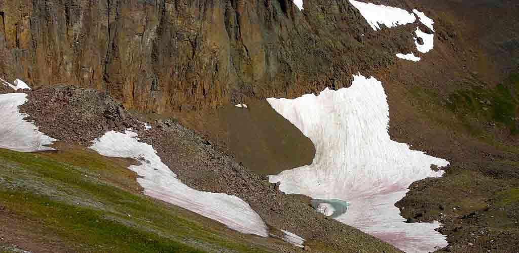
The rugged alpine terrain of Rock Cut exemplifies Trail Ridge Road's dramatic high-elevation landscape. Here, steep rocky slopes with their distinctive reddish-brown earth and scattered snow patches create striking contrasts against sparse green tundra vegetation. Small turquoise meltwater ponds nestled in rocky depressions add compelling foreground elements, showcasing the road's unique position in Colorado's alpine tundra ecosystem above treeline.
5. Alpine Visitor Center (Mile 23.3)
GPS Coordinates: 40.4158°N, -105.7394°W
Elevation: 11,796 feet
Best Time: Variable - excellent all-day shooting opportunities
Subjects: 360-degree mountain panoramas, visitor interaction, architecture
Signature Shots:
- Panoramic Stitching: Multi-frame panoramas of Continental Divide
- Time-lapse: Cloud formation and movement over peaks
- Night Photography: Star trails and Milky Way (summer only)
- Human Element: Visitors experiencing the alpine environment
⚡ WEATHER WARNING
Above treeline, weather changes rapidly and lightning is common. Monitor conditions constantly and retreat to vehicles or buildings if storms develop. Never photograph during lightning activity in exposed areas.
6. Milner Pass Continental Divide (Mile 26.5)
GPS Coordinates: 40.4158°N, -105.7823°W
Elevation: 10,759 feet
Best Time: Late afternoon (3:00-6:00 PM) for western slope lighting
Subjects: Continental Divide sign, geographic significance, directional views
7. Medicine Bow Curve (Mile 31.5)
GPS Coordinates: 40.3694°N, -105.8256°W
Elevation: 10,640 feet
Best Time: Morning (7:00-10:00 AM) for Never Summer Range views
Subjects: Never Summer Mountains, Cache la Poudre River valley
8. Farview Curve (Mile 33.6)
GPS Coordinates: 40.3508°N, -105.8419°W
Elevation: 10,120 feet
Best Time: Afternoon (1:00-5:00 PM) for Grand Lake direction views
Subjects: Kawuneeche Valley, Colorado River headwaters, western views
📷 Camera Settings & Technical Specifications
High-Altitude Photography Challenges
Exposure Considerations:
- UV Filtration: Essential above 10,000 feet - UV rays are 25% stronger
- Contrast Management: Extreme brightness differences between snow and shadow
- Battery Performance: Cold temperatures reduce battery life by 40-50%
- Condensation Control: Gradual temperature changes prevent lens fogging
Recommended Camera Settings
Landscape Photography:
- Aperture: f/8-f/11 for optimal sharpness and depth of field
- ISO: Base ISO (100-200) for maximum image quality
- Shutter Speed: 1/60s minimum to prevent camera shake in wind
- Focus: Hyperfocal distance for foreground-to-infinity sharpness
- Metering: Center-weighted or spot metering for high-contrast scenes
Wildlife Photography:
- Aperture: f/2.8-f/5.6 for subject isolation
- ISO: 400-1600 depending on light conditions
- Shutter Speed: 1/500s minimum for moving animals
- AF Mode: Continuous AF (AI Servo/AF-C) for tracking
- Drive Mode: High-speed continuous for action sequences
Essential Lens Recommendations
Wide-Angle (14-35mm):
- 14-24mm f/2.8: Ultra-wide for expansive vistas
- 16-35mm f/2.8: Versatile wide-angle for varied compositions
- 24-70mm f/2.8: All-purpose lens for general photography
Telephoto (70-400mm):
- 70-200mm f/2.8: Portrait length for wildlife and distant peaks
- 100-400mm f/4-5.6: Wildlife specialist, mountain detail
- 500mm+ super telephoto: For serious wildlife work
🔋 BATTERY TIP
Carry 2-3 spare batteries and keep them warm inside clothing. Cold mountain air dramatically reduces battery performance. Use grip warmers or body heat to maintain battery temperature during shooting.
🌅 Optimal Timing & Lighting Conditions
Golden Hour Photography
Summer Schedule (June-August):
- Sunrise: 5:30-6:30 AM (first light at 5:00 AM)
- Golden Hour Morning: 6:30-8:00 AM
- Golden Hour Evening: 6:30-8:00 PM
- Sunset: 8:00-8:30 PM (alpenglow until 9:00 PM)
Shoulder Season (May & September):
- Sunrise: 6:00-7:00 AM
- Morning Golden Hour: 7:00-8:30 AM
- Evening Golden Hour: 5:30-7:00 PM
- Sunset: 7:00-7:30 PM
Blue Hour & Astrophotography
Blue Hour Timing:
- Morning Blue Hour: 30 minutes before sunrise
- Evening Blue Hour: 20-40 minutes after sunset
- Duration: Approximately 20-30 minutes
- Best Subjects: Silhouettes, twilight landscapes, city lights
Astrophotography Season:
- Best Months: June through August (road open, minimal snowfall)
- Moon Phase: New moon ±3 days for darkest skies
- Milky Way Visibility: 10:00 PM - 4:00 AM (summer)
- Settings: 15-25 second exposures, f/1.4-f/2.8, ISO 3200-6400
🦌 Wildlife Photography Opportunities
Elk Photography (Year-round)
Best Locations:
- Horseshoe Park: Large herds in open meadows
- Moraine Park: Early morning and evening activity
- Kawuneeche Valley: Western slope elk populations
- Deer Ridge Junction: Migration corridor
Optimal Times:
- Dawn Activity: 5:30-8:00 AM (most active period)
- Evening Activity: 5:00-7:30 PM
- Rutting Season: September-October (bugling and behavior)
- Winter Viewing: Lower elevations when road is closed
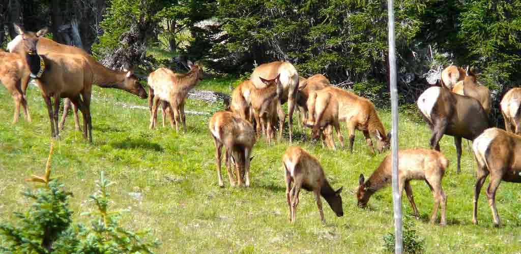
Witnessing elk herds in their natural alpine meadow habitat represents one of Trail Ridge Road's most rewarding photography experiences. These majestic animals, including adults and calves, graze peacefully against the backdrop of dense coniferous forests and rolling hills, offering photographers incredible opportunities to capture Colorado's iconic wildlife in pristine subalpine settings.
Bighorn Sheep Photography (High Country)
Prime Locations:
- Sheep Lakes: Mineral licks, reliable viewing
- Medicine Bow Curve: Cliff environments
- Rock Cut area: Alpine habitat
- Horseshoe Park cliffs: Dramatic rocky terrain
Photography Strategy:
- Safety Distance: Minimum 25 yards (park regulation)
- Telephoto Essential: 400mm+ for quality shots
- Behavioral Shots: Interaction, feeding, climbing
- Environmental Portraits: Animals in alpine habitat context
Small Alpine Wildlife
Pika Photography (Above Treeline):
- Locations: Rock Cut, Alpine Visitor Center, rock fields
- Technique: 100-400mm lens, fast shutter speeds
- Behavior: Listen for calls, watch for movement
- Best Times: Mid-morning when rocks warm up
Marmot Photography:
- Locations: Rock slides, boulder fields, Alpine Visitor Center
- Approach: Slow movements, patience for natural behavior
- Seasonal Activity: Most active July-September
- Composition: Include habitat context in shots
📐 WILDLIFE ETHICS
Maintain required distances: 25 yards from elk and deer, 100 yards from bears and moose. Use telephoto lenses rather than approaching wildlife. Never feed, chase, or harass animals for photographs. Respect closures and wildlife protection areas.
🍂 Seasonal Photography Specialties
Fall Colors Photography (September-October)
Peak Color Timing:
- High Elevations (9,000+ feet): Mid-September
- Mid Elevations (8,000-9,000 feet): Late September
- Lower Elevations (7,500-8,000 feet): Early October
- Duration: 2-3 weeks peak color per elevation zone
Best Aspen Locations:
- Many Parks Curve: Valley aspens with mountain backdrop
- Bear Lake Road: Dense aspen groves
- Kawuneeche Valley: River bottom aspens
- Lily Lake area: Accessible aspen photography
Fall Color Techniques:
- Polarizing Filter: Reduce reflections, saturate colors
- Backlighting: Translucent aspen leaves glow in backlight
- Intimate Landscapes: Focus on smaller compositions
- Abstract Patterns: Trunk patterns, leaf carpets
Spring Wildflower Photography (June-July)
Elevation-Based Bloom Schedule:
- 7,500-9,000 feet: Late May to mid-June
- 9,000-11,000 feet: Mid-June to mid-July
- 11,000+ feet (Alpine): Mid-July to early August
- Peak Bloom: 2-3 week window per elevation
Common Wildflower Species:
- Low Elevation: Columbines, Indian paintbrush, lupine
- Mid Elevation: Mountain aster, fireweed, Rocky Mountain iris
- Alpine Zone: Moss campion, alpine forget-me-nots, sky pilot
Winter & Storm Photography
Winter Access (Limited):
- Road Closure: Typically October to late May
- Accessible Areas: First 8-10 miles from Estes Park
- Snowshoe Access: Beyond closure gates for winter scenes
- Safety Considerations: Extreme weather, avalanche danger
Storm Photography Safety:
- Lightning Safety: Retreat immediately if thunder heard
- Vehicle Shelter: Use car as Faraday cage protection
- Weather Monitoring: Constant awareness of changing conditions
- Emergency Gear: Warm clothing, emergency supplies
🎯 Advanced Photography Techniques
High Dynamic Range (HDR) Photography
Ideal Conditions:
- High Contrast Scenes: Bright snow with dark valleys
- Sunrise/Sunset: Extreme light variation
- Bracket Settings: 5-7 exposures, 1-2 stop increments
- Processing: Natural HDR toning, avoid oversaturation
Focus Stacking for Landscape Detail
Technique Application:
- Foreground-Background Scenes: Wildflowers to distant peaks
- Focus Points: 5-15 images with shifted focus
- Software: Photoshop, Helicon Focus, Zerene Stacker
- Tripod Essential: Absolute stability between frames
Panoramic Photography
Multi-Frame Panoramas:
- Overlap: 30-50% between frames
- Manual Exposure: Lock exposure for consistent lighting
- Focal Length: 35-85mm prevents excessive distortion
- Stitching Software: PTGui, Photoshop, Lightroom
🎨 COMPOSITION TIP
Use leading lines created by the road, ridgelines, and drainage patterns to guide viewers through your compositions. Trail Ridge Road's serpentine path provides natural S-curves that add visual flow to landscape images.
🎒 Essential Photography Gear
Camera Equipment Checklist
Camera Body Requirements:
- Weather Sealing: Protection against mountain weather
- Cold Weather Performance: Reliable operation to -10°F
- High ISO Performance: Clean images at 1600-6400 ISO
- Dual Card Slots: Backup security for irreplaceable shots
Lens Priority System:
- 24-70mm f/2.8: Primary landscape lens
- 16-35mm f/2.8: Wide-angle for expansive vistas
- 70-200mm f/2.8: Wildlife and distant mountain detail
- 100-400mm f/4-5.6: Specialized wildlife work
- Macro lens: Wildflower and detail photography
Support and Accessories
Tripod Requirements:
- Carbon Fiber: Lightweight for hiking, stable in wind
- Height: Minimum 60" extended height
- Weight Rating: 2x camera/lens combination weight
- Leg Locks: Twist or lever locks for gloved operation
Filtration System:
- UV Filters: Essential protection above 10,000 feet
- Polarizing Filter: Reduce reflections, saturate colors
- Graduated ND Filters: Balance bright sky with darker land
- Neutral Density Filters: Long exposure effects
Weather Protection & Comfort
Equipment Protection:
- Rain Covers: Camera and lens protection
- Lens Cleaning Kit: Microfiber cloths, cleaning fluid
- Desiccant Packs: Moisture control in camera bag
- Backup Equipment: Second camera body, spare memory cards
Personal Comfort:
- Layered Clothing: Temperature regulation 7,500-12,000 feet
- Insulated Gloves: Finger dexterity for camera controls
- Sun Protection: Hat, sunglasses, sunscreen
- Emergency Supplies: Food, water, emergency shelter
📱 Modern Photography Tools
Smartphone Photography Apps
Planning Applications:
- PhotoPills: Sun/moon positioning, hyperfocal calculator
- Sun Surveyor: 3D sun and moon tracking
- Weather Underground: Detailed mountain weather forecasts
- Tide & Weather Pro: Sunrise/sunset timing with weather
Field Applications:
- Hyperfocal Pro: Depth of field calculations
- Magic Hour: Golden hour and blue hour timing
- Light Meter: Exposure measurement backup
- GPS Essentials: Coordinate recording and navigation
Post-Processing Workflow
RAW Processing:
- Adobe Lightroom: Primary RAW development and organization
- Capture One: Alternative RAW processor with excellent color
- Luminar AI: AI-powered sky replacement and enhancement
- DxO PhotoLab: Superior noise reduction and lens corrections
Specialized Processing:
- Photoshop: Advanced compositing and retouching
- Aurora HDR: Specialized HDR processing
- Nik Collection: Color Efex Pro, Silver Efex Pro filters
- Topaz Labs: AI noise reduction and sharpening
🏢 Professional Photography Services
Guided Photography Workshops
Rocky Mountain Photography Adventures
Professional instruction with local knowledge
Contact: (970) 555-1234
Website: RMPhoto.com
Specialties: Wildlife photography, landscape composition, technical instruction
Trail Ridge Photography Tours
Small group workshops focusing on alpine photography
Contact: (970) 555-2345
Services: Sunrise tours, wildlife workshops, post-processing instruction
Duration: Half-day and full-day options available
Equipment Rental & Services
Mike's Camera (Denver/Boulder)
Professional equipment rental and sales
Address: Multiple Front Range locations
Contact: (303) 333-3200
Website: MikesCamera.com
Services: Camera rental, lens rental, equipment sales
Estes Park Camera Shop
Local equipment and emergency services
Address: 123 Elkhorn Ave, Estes Park, CO 80517
Contact: (970) 586-3456
Services: Memory cards, batteries, basic repairs, local advice
💾 BACKUP STRATEGY
Shoot RAW+JPEG and use dual card slots if available. Back up images to cloud storage when in areas with cell service. Consider a portable storage device for extended trips without computer access.
🔗 Photography Planning Resources
Trail Ridge Road Specific:
📞 Road Conditions: (970) 586-1222
🌐 Current Status: NPS Road Status
📱 NPS Mobile App: Real-time alerts and information
Weather and Conditions:
🌤️ Mountain Weather: NWS Rocky Mountain National Park Forecast
📹 Live Webcams: Park Webcam System
🛣️ Road Cameras: CDOT Traffic Cameras
Related Photography Guides:
🦌 Wildlife Photography Guide
🏔️ Colorado Scenic Drive Photography
🍂 Fall Colors Photography Guide
📸 CAPTURE THE EXTRAORDINARY
Trail Ridge Road offers photography opportunities that exist nowhere else on Earth - accessible alpine environments, diverse ecosystems, and dramatic elevation changes create subjects and lighting conditions that inspire and challenge photographers at every level. Respect the environment, prioritize safety, and prepare thoroughly to capture images that convey the majesty and fragility of America's high country.